FergWorld : PIREPS : KLN-94 IFR GPS

By Ryan Ferguson
| Pros: |
Great price, great features, easy to use for IFR |
| Cons: |
Small screen, slow CPU |
| Bottom line: |
Great bang for the buck |
| Rating: |
  Four stars (out of five)
 |
|
|
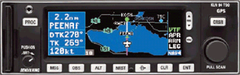
The Bendix-King KLN-94. It's not a brand new, cutting edge IFR GPS. It's not nearly as big, cool, or sexy as the Garmin 530. It's also not nearly as popular. If anything, it could be called trailing edge compared to today's equipment.
I confess that I'm a little bit baffled. Mr. Ferguson is not poor, but he is not a rich man by any stretch of the imagination. Just who has the money for a Garmin 530 in an aircraft worth, at most, $200,000 on the market today? The installation of this product will cost at least 10% of the value of the airplane, and you're virtually guaranteed never to recoup it. Heck, I've seen these things in thirty year old Cessna 182s worth no more than $75,000 tops! HUH?! I'll be the first one to admit I'd love to have one of these fantastic tools in the cockpit. But let's be realistic… just what does the pilot need from an IFR GPS? And what's it worth? I'm simply not willing to throw away a lot of money on something pretty.
For me, it was simple.
- IFR Enroute (of course), terminal, and approach-certified.
- Moving map.
- Color.
- Easy to use.
- A value proposition (INEXPENSIVE!)
These requirements led me to the KLN-94, which, as of late 2002, still retails for $4500 or those whereabouts, but can be had reconditioned or refurbished for half that amount.
I found one for sale. It had just been removed from a brand new Cessna 182S. The cost: $2700, or roughly 20% of the cost of the Garmin 530. Marvin, you've got a deal.
Installing it
I chose the KLN-94 in the midst of a panel upgrade which included the following: a new laser cut panel with the 'standard T' configuration for the sixpack, neatly ordered rows and switches (instead of scattered everywhere), an EDM-760 engine monitor/fuel flow system, secondary air-powered attitude indicator, and a pair of new KX-155 nav/coms. This also featured two new CDIs (one with glideslope) and a GPS annunciator that allowed me to send GPS or radio nav signals to CDI #1. New ring lighting was added to the instruments, and my engine gauge cluster was illuminated with wafer-thin luminescent paper (very slick!) The KLN-94 was able to accept input from the fuel flow module on the EDM-760 which meant that I'd know, at a glance, how many gallons I'd have remaining on board at my destination. Overall I felt the upgrade improved the utility and safety of the aircraft, and the KLN-94 was its centerpiece. Most importantly, this was an upgrade which was high on the value curve for avionics. It's hard to get your money back out of dollars spent on this stuff, and I wanted the maximum bang for the buck I could get. Installation of the GPS itself was reasonably inexpensive, approximately $1,500 worth of labor.
Using it
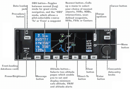
I like several things about the interface. First, I'm a klutz and I've killed a few too many brain cells learning to fly as it is. So, the GPS really needs to be easy in general use – which it is. Second, it's very easy to build and load flight plans. This is good for a frequent flier like me who flies several common flight plans repeatedly. Third, reconfiguring due to an unexpected amendment in routing/clearance or approach is a cinch, in many cases not even requiring keystrokes if the navaids are located near the aircraft's present position. And finally, loading and reloading approaches is very easy. I daresay for basic "vectors to final" style approaches one could properly load and fly an approach intuitively just by starting with the dedicated 'PROC' button on the left side of the unit.
The colors are crisp and clear, making the display easy to use despite its relatively small size. The panel of a Twin Comanche does not have an abundance of space, and frankly, the size was perfect for me.
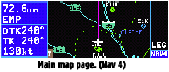
There are two basic modes you'll use enroute – leg mode, or OBS mode.
Leg mode simply means that waypoints sequence automatically in the present flight plan, or if you enter a waypoint which is not in the flight plan and press the Direct To (D->) button, it'll remain the active waypoint until you change it.
OBS mode is common on most IFR GPS' nowadays. It simply means that any given waypoint or fix (even a user-defined fix) can become a "virtual VOR" in which you can "tune in" and select a "radial" with a virtual CDI. For example, say you want to fly a hold over an NDB; you simply enter the NDB's identifier into the GPS, activate OBS mode, and either twirl CDI #1 until you get the selected "virtual radial" or twirl the knob on the GPS. Now the needle on the CDI acts just like a radial, along with the FROM/TO flag. Best of all, the inbound and outbound course from the waypoint is painted on the GPS, allowing you to very easily visualize the hold. It's almost like cheating! All you have to do is make your ground track match up with the inbound course. I try not to look at the screen when practicing holds because it's just too simple.
One of the best and simplest interface innovations with this GPS has to be the manner in which the user can scan through flight plan waypoints and nearby navaids/airports by pulling the inner knob out and twirling. When doing this, a line is drawn on the moving map from the airplane icon (your present position) to nearby waypoints as you flip through them, and their 3 letter identifier appears in the lower right of the screen. You can press enter to learn more information about them (runway length, comms, freqs, etc.) or press the Direct-to button to go directly to the waypoint. When ATC clears you to skip a navaid and clears you direct to the next VOR on your route, you simply pull the knob out and surf over to it. No button pushing. Nice.
Enroute
 I have a confession to make. I used my Garmin 295 handheld GPS when flying IFR… a lot. Oh, of COURSE I was only using it to augment situational awareness! But truth be told, I was using that little unit to get me around in the murk, despite having my VORs running second string. Do you think I'm a bad pilot?
I really didn't mind using it in that fashion, to be honest. But there are definitely some disadvantages. You have to play the "Please give me a vector" game with ATC whenever you want to go direct. And, of course, you really shouldn't rely totally on a single device – any single device. The only way to fly IFR with a handheld GPS is to include it in your bevy of instrument tools and always have backup nav available.
There were other disadvantages, too. I run generators in my airplane and I have a little electrical gremlin somewhere that causes some slight irregularities in the voltage. The 295 would occasionally lock up, and reboot required removing the batteries and reinstalling them – not something to do when flying single pilot IFR. The 295 also has a perfect seal which will "pressurize" at altitude, so that when you descend, none of the buttons will work because of the air trapped inside. But the biggest single disadvantage is not being able to file IFR as a PA30/G. That little G gives you the ability to cut straight through to your destination, in many cases getting a "truly" direct course to where you're going. The way I see it, that effectively makes my airplane faster.
Other than that – and OBS mode for assistance with holds – using the panel-mounted GPS enroute is not significantly better than a hand-held GPS. Point where you want to go and keep going in that direction.
Approach
GPS approaches. I'd never flown one, didn't know what to expect. They're surprisingly easy, if you're set up properly. There are, however, a few gotchas to be aware of.
It goes without saying that the pilot needs to, at the very least, spend a few evenings with the manual before attempting an approach in the soup. The GPS is not hard to use in approach mode, but it does exhibit the same weakness that all panel-mount IFR GPS' have, which is lack of standardization. At this point in time, the only option is to get comfortable with the specific box you're flying. That's what I did.
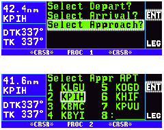 Loading an approach is easy. You start with the dedicated 'PROC' (short for 'Procedure') button on the left side of the unit's faceplate. You first get to select whether you want an approach, DP, or STAR. After selecting approach, a list of nearby airports pop up, with your selected destination or enroute airports appearing first. Push 'Enter' to select the airport at which you want to shoot an approach. Now you get your choice of approaches – all of the available approaches should be listed in most cases. Everything from ILS to NDB to VOR to RNAV are at your fingertips. A small "GPS" icon appears to the right of the approach name if the approach can be flown with GPS. For other approaches, you can merely "monitor" your approach with the GPS.
Most VOR, NDB, and RNAV approaches can be flown with the GPS. Select which approach you would like, then arm the approach by either selecting an IAF or "Vectors to Final" (which you'll get most of the time.) The only gotcha here is that you have to be within 30nm of your destination for the GPS to arm. The remote annunciator panel lights up with "ARM" and you're in business. The only thing left to do (if you selected vectors) is activate the vectors when you're given an intercept heading. From there the GPS takes over.
"DME arcs [using the GPS] are interesting, to say the least. No need to cut 10 degree turns, look at the DME, adjust course for wind, etc."
The GPS approach must be the easiest of all non-precision approaches one can fly. The beauty of satellite navigation is that you don't have to worry about VOR signal strength, terrain blocking nav signals, or the inherent lack of accuracy in a VOR or NDB approach in which the navaid is located off-field. The GPS goes to approach sensitivity (which is +/- 0.3nm full deflection left or right) instead of enroute sensitivity (+/- 5nm full deflection left or right.) Now you simply fly the needle and at the missed approach point you should see the runway right in front of you, assuming the visibility and ceilings cooperate.
The missed approach – very easy. Push the D-> (direct-to) button. The missed approach holding point is already loaded into memory. Push enter. Now you've selected the waypoint at which you'll need to hold. Follow your missed approach instructions. Nothing could be easier.
The gotchas: make sure your CDI is set to receive GPS signals. If you've loaded a localizer frequency into a King KX-155, the auto-lockout feature prevents the GPS from talking to the CDI. Another gotcha: forgetting to activate vectors after arming them. A third gotcha: being assigned an IAF when cleared for the approach which also serves as the MAHP (missed approach holding point.) The GPS knows the difference between the two. For example, let's say FUGLY is an IAF/MAHP. The KLN-94 will notate the IAF as FUGLYi. The MAHP will be notated as FUGLYm. Make sure you select the proper fix.
DME arcs are interesting, to say the least. When you load an approach which features a DME arc, the GPS allows you to intercept the arc at any point on the arc (although it'll probably be an IAF), and you'll be warned when to turn and thereafter given course guidance to stay on the arc! No need to cut 10 degree turns, look at the DME, adjust course for wind, etc. You just point the nose where the GPS tells you to point it and keep the needle centered. You'll want to try this a few times before doing it in actual instrument conditions, but it's pretty slick.
Neat extras
I love the integration between the GPS and the EDM-760. I always know my exact fuel status down to the gallon at any moment, and predicition is much easier. Utility of the aircraft is enhanced because I can plan fuel stops with greater accuracy.
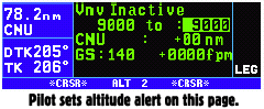 I also like the altitude alert. I was looking at buying a standalone altitude alert when I learned that the KLN-94 includes one. Using the barometric pressure input from your sensitive altimeter, you simply dial in the kollsman window setting and voila! You're set for altitude alarms when you come up on, arrive at, or overshoot your intended altitude. Anyone who flies IFR frequently knows that the first step to take when assigned a new altitude is to read back the instruction and immediately dial it into your altitude alert, or failing that, notating it somehow. The unit uses a sequence of numbered beeps to inform you whether you're within 1000 feet, arriving at your intended altitude, or deviating from it.
It's very easy to return to the moving map page at any time, just by pressing the range button (the oblong up/down arrow on the right side of the faceplate.) Holding this button down for a few seconds puts the unit into "autozoom" mode, which will automatically set the correct zoom range to include all of your flightplan waypoints. This is a nice feature when flying an approach. Press "CLR" once to remove land data and de-clutter the screen.
What I don't like
There's no cursor. A Garmin 295 (color handheld GPS) lives on my copilot yoke and I still use it, primarily because I can scroll around on the map to highlight an airport, a geographic feature, measure distance between two points, etc. Those features aren't available on the KLN-94 because there's no cursor. (Where would they put a cursor? I don't know, I just wish I could scroll around somehow.) When a passenger asks, "What's the name of that lake off to our left?" I sometimes have to fire up the handheld GPS to answer the question.
My other beef: the unit's microprocessor is a tad on the sluggish side. When turning to a new heading the indicated ground track can lag behind by a number of seconds. I've learned that corrections on an approach in which I'm monitoring ground track must account for this lag.
Other than that, I am very pleased, especially with the utility I've gained for the dollars spent.
Summary
It's a nice tool for the right price. When it comes to avionics and aircraft ownership, I think that's where the key to utility and enjoyment of your investment really has to lie. It's not the greatest GPS on the block, but in the bang-for-the-buck category, it's outstanding. And perhaps most importantly, you get 98% of the utility of the "big screen" anyway! My opinion: thumbs up.
Questions or comments? Email me at ryan@fergworld.com. 
|